
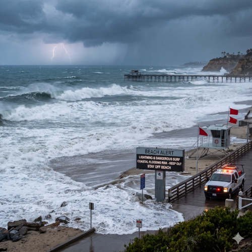
A weather alert issued for coastal areas of San Diego County and Orange County warned beachgoers about cloud-to-ground lightning, dangerous swimming conditions and possible coastal erosion early Friday, November 13, 2026. The National Weather Service (NWS) San Diego issued the Beach Hazards Statement at 3:02 a.m. Pacific time, with the alert scheduled to remain in effect until 8 a.m.
The warning came as a band of thunderstorms moved toward the Southern California coastline. Although the immediate lightning threat was expected to diminish after 8 a.m., the coastal risk was not over. The NWS also highlighted elevated surf and high tides near seven feet that could contribute to localized beach erosion and water overflowing onto parking lots and boardwalks.
A separate High Surf Advisory was scheduled to begin at 4 p.m. Friday and continue through 10 a.m. Sunday for San Diego County coastal areas and Orange County coastal areas. Forecasters expected breaking waves of 5 to 7 feet, with sets reaching 8 to 9 feet at west-facing beaches, along with a high risk of rip currents. forecast.weather.gov
What the Beach Hazards Statement Means for Coastal Residents
A Beach Hazards Statement is designed to alert the public to dangerous coastal conditions that may affect people using beaches and nearby waterfront areas.
In this case, the immediate concern was a band of thunderstorms moving ashore. The NWS warned that cloud-to-ground lightning was expected, creating a risk for swimmers, surfers, fishermen, beach visitors and people working near the shoreline.
Lightning is particularly dangerous around open beaches because people may have few nearby places to take shelter. A storm does not have to be directly overhead for lightning to pose a threat.
The NWS expected the thunderstorms and lightning threat to diminish after 8 a.m. Friday. However, the expiration of the Beach Hazards Statement did not mean that all coastal hazards had ended. The separate High Surf Advisory was scheduled to begin later Friday afternoon.
That distinction is important for residents and visitors planning beach activities. Different weather alerts can cover different hazards and time periods.
High Surf Advisory Forecast for San Diego and Orange County
The NWS San Diego office issued a High Surf Advisory for San Diego County coastal areas and Orange County coastal areas.
The advisory was scheduled to take effect at 4 p.m. Friday, November 13, and remain in effect until 10 a.m. Sunday, November 15.
Forecasters expected:
- Breaking waves of 5 to 7 feet.
- Sets reaching 8 to 9 feet at west-facing beaches.
- A high risk of dangerous rip currents.
- Localized beach erosion.
- Possible water overflow onto parking lots and boardwalks.
The NWS warned that inexperienced swimmers should remain out of the water because of dangerous surf conditions. Strong waves can knock people off their feet, pull swimmers away from shore and create hazardous conditions even for visitors who remain close to the beach.
The surf was expected to begin weakening Sunday afternoon. However, elevated waves could continue along west-facing beaches into Monday.
For people planning weekend trips, this means checking the latest coastal forecast before visiting the shoreline. A beach that appears relatively calm during one period may experience stronger waves later.
Seven-Foot High Tides Could Increase Coastal Flooding Risk
Along with thunderstorms and high surf, the NWS highlighted the possibility of localized coastal flooding.
Adjusted high tides were expected to approach seven feet. Although tides were forecast to be falling during the relevant period, the combination of elevated water levels and strong surf could still cause problems in exposed coastal locations.
Large waves can push seawater beyond the normal shoreline, especially when they arrive during higher tides. Water may reach low-lying beach access points, parking areas, walkways and boardwalks.
This type of coastal overflow does not necessarily mean widespread flooding across an entire community. The risk may be concentrated in vulnerable sections of the coastline.
However, even localized flooding can disrupt beach access, damage property and create unsafe conditions for pedestrians and drivers.
Coastal erosion is another concern. Strong waves can remove sand from beaches and reshape sections of the shoreline. Areas with exposed walkways, seawalls and other coastal infrastructure may experience greater impacts.
Property owners and businesses close to the shoreline should pay attention to local conditions, particularly during high tides and periods of stronger surf.
Rip Currents Create Dangerous Swimming Conditions
Rip currents are among the most serious hazards associated with high surf.
A rip current is a narrow, powerful flow of water moving away from the shore. It can pull swimmers away from shallow water and make it difficult to return to the beach.
These currents can develop even when the ocean does not appear exceptionally rough. Visitors who underestimate the strength of moving water may quickly find themselves in trouble.
The NWS forecast specifically highlighted a high rip current risk for the affected coastal areas.
Beachgoers should avoid entering the water when surf conditions are dangerous. Inexperienced swimmers should remain out of the ocean during the advisory.
People should also avoid assuming that being a strong swimmer eliminates the risk. Powerful currents and breaking waves can overwhelm people with different levels of swimming experience.
Visitors who notice someone struggling in the water should alert lifeguards or emergency services rather than entering dangerous surf themselves.
Lightning Safety: What Beachgoers Should Do
The early-morning thunderstorm threat made lightning safety an important part of the weather alert.
The Centers for Disease Control and Prevention advises people to move indoors when they hear thunder or see lightning. It also recommends waiting at least 30 minutes after the last thunder before resuming outdoor activities.
People at the beach should take these precautions:
- Leave the water immediately: Swimming, surfing, wading and boating are unsafe during thunderstorms.
- Move away from the shoreline: Do not remain on an exposed beach when lightning threatens.
- Find proper shelter: Move into a substantial enclosed building or a hard-topped vehicle with the windows closed.
- Avoid open shelters: Open-sided picnic shelters, beach umbrellas and small sheds do not provide safe lightning protection.
- Wait after the storm: Stay in a safe location for at least 30 minutes after the last thunder before returning outdoors.
The CDC and National Weather Service emphasize that people should not wait for rain to begin before seeking shelter. Lightning can strike even when rainfall is not occurring at a person’s exact location.
For additional guidance, visitors can review the CDC’s official lightning safety recommendations.
What San Diego and Orange County Residents Should Expect This Weekend
The coastal weather outlook includes several hazards that may affect weekend recreation and travel.
Friday morning’s thunderstorms and lightning threat were expected to ease after 8 a.m. However, the High Surf Advisory was scheduled to begin at 4 p.m., bringing another period of dangerous coastal conditions.
Saturday and Sunday were expected to bring large breaking waves, with the strongest sets reaching 8 to 9 feet at some west-facing beaches.
The combination of high surf, rip currents and elevated tides could affect popular beach areas throughout the two counties.
Visitors should pay attention to local beach warnings, posted restrictions and lifeguard instructions. Some beaches may experience more severe conditions than others because wave exposure and shoreline geography vary.
The NWS also indicated that surf could remain elevated along west-facing beaches into Monday, even as conditions begin to improve Sunday afternoon.
Residents should therefore avoid assuming that the end of the advisory period means every beach is immediately safe.
How the Weather Alert Could Affect Beach Businesses and Coastal Property
Dangerous surf and coastal flooding can affect more than swimmers and surfers.
Restaurants, hotels, parking facilities, waterfront shops and other businesses near the ocean may experience temporary disruptions when waves or seawater reach public access areas.
Localized beach erosion can also affect walkways and other infrastructure. Businesses that depend on beach access may need to respond to temporary restrictions or changing conditions.
Property owners should monitor local government and emergency management updates if their buildings or parking areas are close to exposed sections of the shoreline.
People planning coastal travel should also consider checking local road and parking conditions before leaving. Water overflow can make some low-lying areas difficult to access.
For homeowners and business operators, it is important to understand that standard property insurance policies may have specific exclusions and limitations for flood damage. Anyone concerned about coastal flood insurance coverage should review their policy documents and speak with their insurer about applicable protections and exclusions.
Where to Check the Latest San Diego and Orange County Beach Weather Alerts
The National Weather Service remains the primary source for official weather alerts, forecasts and coastal hazard updates.
Residents can check the latest information through the NWS San Diego office and its official forecast products.
Visitors should also follow local beach safety notices and instructions from lifeguards. Conditions can change quickly, especially when thunderstorms, strong surf and changing tides occur close together.
The latest alert information should be checked before swimming, surfing, fishing or taking part in other coastal activities.
Frequently Asked Questions
Is there a Beach Hazards Statement for San Diego County on November 13, 2026?
The NWS San Diego issued a Beach Hazards Statement at 3:02 a.m. Pacific time Friday, November 13, for San Diego County Coastal Areas and Orange County Coastal Areas. It was scheduled to remain in effect until 8 a.m.
Why did the NWS issue the beach weather alert?
The alert warned about cloud-to-ground lightning as a band of thunderstorms moved toward the coast. It also highlighted dangerous swimming and surfing conditions, possible beach erosion and localized coastal overflow.
How high could waves get in San Diego and Orange County?
The separate High Surf Advisory forecast breaking waves of 5 to 7 feet, with sets reaching 8 to 9 feet at west-facing beaches.
When does the High Surf Advisory begin?
The advisory was scheduled to begin at 4 p.m. Friday, November 13, and continue until 10 a.m. Sunday, November 15.
Are rip currents expected along Southern California beaches?
Yes. The NWS forecast identified a high rip current risk for the affected San Diego County and Orange County coastal areas.
Is it safe to swim during a thunderstorm?
No. People should leave the water and move into a substantial enclosed building or a hard-topped vehicle when lightning threatens. The CDC recommends waiting at least 30 minutes after the last thunder before resuming outdoor activities.
Could high tides cause beach flooding?
Yes. Adjusted high tides near seven feet, combined with elevated surf, could produce localized beach erosion and seawater overflow into parking lots and boardwalks.
Final Outlook: Coastal Hazards Continue Beyond the Morning Lightning Alert
The early-morning Beach Hazards Statement highlighted the immediate danger of thunderstorms and cloud-to-ground lightning along the San Diego and Orange County coastlines. Although that statement was scheduled to expire at 8 a.m. Friday, a separate High Surf Advisory was set to begin later in the afternoon.
With waves forecast to reach 8 to 9 feet in some areas, a high rip current risk and the possibility of localized coastal erosion, beachgoers should remain cautious throughout the weekend.
Checking official weather alerts, following lifeguard instructions and avoiding dangerous water conditions are essential steps for anyone visiting Southern California beaches.