

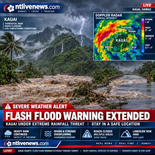
US Weather News : Heavy rainfall continued across Kauai on Saturday, October 31, prompting the National Weather Service (NWS) to extend its flash flood warning until 8:45 p.m. Hawaii time. Rivers were rising, roads were affected by floodwaters, and officials urged residents and visitors to avoid streams, low-lying areas and dangerous driving conditions.
The warning covered the entire island of Kauai in Kauai County. At 5:08 p.m., Doppler radar and automated rain gauges showed heavy rain falling across the island at rates of approximately 1 to 2 inches per hour. Water levels at the Hanalei River and South Fork Wailua River gauges remained elevated, with forecasters warning that they could rise further if the rain continued.
Kuhio Highway near the Hanalei Bridge remained closed because of flooding. The repeated warning extensions highlighted the seriousness of the weather situation, particularly for communities near rivers, streams and flood-prone roads.
The emergency also raised concerns about possible heavy showers moving toward Oahu overnight, although forecasters said conditions could change as the weather system moved across the Hawaiian Islands.
National Weather Service Extends Kauai Flash Flood Warning Until 8:45 p.m.
The National Weather Service in Honolulu extended the flash flood warning at 5:08 p.m. on October 31. The updated alert remained in effect until 8:45 p.m. Hawaii time.
According to the warning, heavy rainfall was affecting the entire island. Radar observations and automated rain gauges indicated that precipitation was falling at rates between 1 and 2 inches per hour.
The NWS also reported elevated water levels at the Hanalei River and South Fork Wailua River. These readings were particularly important because continued rainfall could cause rivers and streams to rise quickly, increasing the danger of flooding in nearby communities.
Forecasters warned that flash flooding was already occurring or could begin shortly in affected areas. The warning included the entire island of Kauai, meaning residents and visitors across the island needed to remain alert.
Flash floods can develop quickly when intense rainfall overwhelms rivers, drainage systems and low-lying areas. Even locations that do not normally experience flooding can become dangerous during periods of sustained heavy rain.
Kuhio Highway Closed Near Hanalei Bridge as Floodwaters Affect Travel :
One of the major transportation concerns during the emergency was the closure of Kuhio Highway near the Hanalei Bridge.
The highway had been closed because of floodwaters from around 12:45 p.m. on Saturday. Subsequent weather updates confirmed that the closure remained in place during the afternoon and early evening.
The road is an important route for people traveling through the Hanalei area. Its closure created disruption for residents, visitors and other motorists who needed to travel between communities.
Kauai County also reported that a section of Kaumualii Highway near Halfway Bridge in the Knudsen Gap area was operating under alternating traffic conditions because of flooding. Police officers were present to manage vehicles moving through the affected section.
Officials additionally reported ponding, poor visibility and other hazardous driving conditions across the island.
These conditions can make even familiar roads dangerous. Floodwater can hide damaged pavement, debris and changes in road depth. Drivers may also underestimate how quickly moving water can push a vehicle off the road.
Motorists were advised to avoid flooded routes and follow official road closure instructions rather than attempting to cross water-covered sections.
Why the Hanalei and Wailua River Levels Matter
The Hanalei River and South Fork Wailua River were among the locations receiving particular attention from forecasters.
Both waterways can respond to periods of intense rainfall, and rapidly rising water levels can threaten nearby roads, trails and low-lying properties.
The NWS specifically warned that stream gauges remained elevated and could rise further as heavy showers continued.
This matters because flash flooding does not always require hours of continuous rainfall. When rain falls at a rate of 1 to 2 inches per hour, water can accumulate quickly, especially in areas with steep terrain and limited drainage capacity.
People near rivers and streams should never assume that a waterway is safe simply because it appears calm at a particular moment. Water levels can change rapidly, and strong currents may carry debris.
Kauai Opens Community Refuge Area in Hanalei
As heavy rain continued, Kauai County officials confirmed that a community-led refuge area at Hale Halawai in Hanalei had opened.
The facility provided an emergency option for people who needed a place to go during the dangerous weather. However, officials made clear that the refuge area did not operate as a fully equipped emergency shelter.
It did not provide:
- Food or drinking water.
- Bedding or sleeping supplies.
- Medications.
- Personal caregivers.
- Medical staff.
Anyone choosing to use the refuge area was advised to bring essential supplies and personal necessities.
County officials described refuge areas as evacuation options of last resort. They also noted that sheltering in place could be appropriate when a home or other structure was sound and located outside a flood-prone area.
Residents should consider local conditions, official evacuation instructions and the safety of their buildings before deciding whether to remain at home or relocate.
The availability of a refuge area does not mean that residents should wait until roads become dangerous before making a decision. Anyone who needs to leave should do so while travel conditions remain safe.
Weather System Could Bring More Showers to Oahu
Although Kauai experienced the most serious flooding during Saturday’s emergency, forecasters also monitored the possibility of additional heavy showers moving toward Oahu.
The NWS said an approaching disturbance, combined with abundant moisture and a surface trough, had contributed to heavy showers and isolated thunderstorms over Kauai and Niihau.
Some of this activity could affect Oahu overnight into Sunday morning.
Oahu had also experienced persistent showers, although forecasters said rainfall rates and stream-gauge responses had not shown the same level of concern as those observed on Kauai at the time of the forecast discussion.
The weather outlook suggested that conditions could change as the system moved eastward.
What Happens After the Heavy Rain System Moves Away?
The NWS forecast indicated that the tail end of a front would move down the Hawaiian island chain from late Sunday through Monday.
This system was expected to bring breezy northeasterly trade winds and drier air behind it.
However, the arrival of drier air does not necessarily mean that all weather-related risks disappear immediately. Water levels may remain elevated after rainfall decreases, and roads can continue to experience hazardous conditions.
Forecasters also expected breezy easterly trade winds to bring periods of showers to windward and mountainous areas during the rest of the week.
Residents and visitors should continue checking local weather updates before traveling, hiking or spending time near streams and coastal areas.
Tropical Weather System in the East Pacific Also Under Monitoring
Alongside the heavy rainfall affecting Hawaii, forecasters were monitoring a separate weather disturbance far southeast of the islands in the East Pacific.
The National Hurricane Center reported a 40% chance of tropical cyclone formation within seven days for the system described in the weather coverage.
The disturbance was expected to move west-northwest toward the Central Pacific, with the possibility of gradual development later in the following week.
However, a chance of tropical cyclone formation does not mean that a storm has already formed or that it will necessarily approach Hawaii.
Forecast tracks, timing and intensity can change as weather systems develop. Residents should rely on updates from the National Hurricane Center and the Central Pacific Hurricane Center for authoritative information.
Safety Guidance :
Flash flooding can become life-threatening with little warning. Residents, tourists, campers and hikers should take official alerts seriously, especially when rainfall remains intense and river levels are rising.
The National Weather Service advises people to turn around rather than drive through flooded roads. Even shallow-looking water can conceal strong currents, damaged road surfaces or debris.
Important precautions include:
- Avoid flooded roads: Never drive through water covering a roadway.
- Stay away from rivers: Keep clear of streams, creeks and riverbanks during heavy rainfall.
- Follow road closures: Do not bypass barricades or attempt to cross closed sections of highway.
- Monitor official alerts: Check National Weather Service warnings and Kauai County emergency announcements.
- Prepare essential supplies: Keep drinking water, medications, important documents and emergency necessities accessible.
- Follow evacuation instructions: Leave early if authorities direct residents to evacuate.
- Avoid hiking during dangerous conditions: Trails near streams and drainage channels can become hazardous quickly.
Where to Check Official Kauai Weather and Emergency Updates
Residents can monitor changing conditions through the National Weather Service Honolulu office and Kauai County emergency management announcements.
The county also provided a road-condition information number, 808-241-1725, for updates on closures and traffic conditions. For weather information, residents can use the NWS automated weather line at 808-245-6001.
People should reserve emergency telephone services for genuine emergencies.
Frequently Asked Questions About the Kauai Flash Flood Warning
1. How long was the Kauai flash flood warning extended?
The National Weather Service extended the warning until 8:45 p.m. Hawaii time on Saturday, October 31, 2026.
2. Why did the National Weather Service extend the warning?
Heavy rain continued across Kauai at rates of approximately 1 to 2 inches per hour. River gauges at the Hanalei River and South Fork Wailua River remained elevated, increasing the risk of additional flooding.
3. Was Kuhio Highway closed near Hanalei Bridge?
Yes. Kuhio Highway near the Hanalei Bridge remained closed because of floodwaters during the reported emergency.
4. Did Kauai open an emergency refuge area?
Yes. A community-led refuge area at Hale Halawai in Hanalei opened. Officials advised visitors to bring their own food, water, medications and other essential supplies because the facility did not provide those services.
5. Could the heavy rain affect Oahu?
Yes. The National Weather Service said showers and thunderstorms affecting Kauai and Niihau could move toward Oahu overnight into Sunday morning.
6. Is a tropical cyclone expected to hit Hawaii?
The National Hurricane Center was monitoring a separate disturbance in the East Pacific with a 40% chance of tropical cyclone formation within seven days. That probability did not confirm that a cyclone would form or strike Hawaii.
Conclusion
The repeated extension of the Kauai flash flood warning on October 31 reflected continuing heavy rainfall, rising river levels and dangerous road conditions across the island.
With Kuhio Highway closed near the Hanalei Bridge, another section of highway operating under alternating traffic and a community refuge area open in Hanalei, local authorities urged residents and visitors to remain cautious.
The immediate priority during flash flooding is personal safety. People should avoid rivers and streams, stay away from flooded roads and follow instructions from emergency officials.
Although the warning was scheduled to expire at 8:45 p.m. Saturday, conditions and official alerts can change. Residents should check the latest National Weather Service and Kauai County announcements before making travel or safety decisions.
References :
- National Weather Service — Official Kauai Flash Flood Warning
- County of Kauai — Flash Flood Warning and Road Closure Update, October 31, 2026
